2026.08.19 (수) 20:15




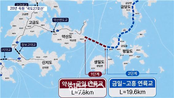 20년 숙원 국도 27호선 / 사진제공=완도군 |
완도군의 20년 숙원인 국도 27호선 약산~금일 연륙교 건설사업이 예비타당성조사라는 첫 관문을 넘을 수 있을지 지역사회의 관심이 집중되고 있다.
약산~금일 연륙교는 단순히 섬과 섬 사이에 다리 하나를 놓는 토목사업이 아니다. 배편에 의존해 온 금일읍 주민의 교통기본권과 응급의료 접근성을 보장하고, 완도와 고흥 사이에서 끊긴 남해안 국가도로망을 연결하는 대형 사회간접자본(SOC) 사업이다.
정부는 완도 약산도에서 금일도까지 7.8㎞ 구간을 완도~고흥 해안관광도로 건설사업의 1단계로 추진하고 있다. 추정 사업비는 4,099억 원이며, 현재 한국개발연구원(KDI)의 예비타당성조사가 진행 중이다.
완도~고흥 해안관광도로 전체 사업은 약산에서 금일과 금당을 거쳐 고흥 거금도까지 이어지는 총연장 27.4㎞ 규모다. 전체 사업비는 9,008억 원으로 추산된다.
이 가운데 1단계 약산~금일 구간은 7.8㎞, 2단계 금일~금당~고흥 거금 구간은 19.6㎞다. 2단계 추정 사업비는 4,909억 원이다.
배가 멈추면 통학·통원·생업도 멈춘다
현재 금일읍 주민들이 약산과 완도 본섬 방면으로 이동하려면 여객선과 차량을 번갈아 이용해야 한다.
평상시에도 배 운항시간에 맞춰 이동해야 하지만 태풍과 풍랑, 짙은 안개 등으로 여객선 운항이 통제되면 주민들의 발이 사실상 묶인다. 병원 진료와 통학, 행정업무, 생업 활동은 물론 생활필수품과 각종 물자의 운송까지 바다 상황에 영향을 받는다.
관광객과 외지인은 불편하면 일정을 변경할 수 있지만, 섬 주민에게 배편은 선택 가능한 관광 교통수단이 아니라 일상생활을 유지하기 위한 유일한 이동수단에 가깝다.
따라서 약산~금일 연륙교 건설은 이동시간을 단축하는 편의사업을 넘어 금일읍 주민이 날씨와 선박 운항시간에 지나치게 구속되지 않고 이동할 권리를 보장하는 사업으로 평가해야 한다.
응급환자에게 다리는 ‘생명도로’
약산~금일 연륙교의 필요성이 가장 절박하게 드러나는 분야는 응급의료다.
금일읍에서 중증 응급환자가 발생하면 섬 안에서 치료가 어려운 경우 육지의 의료기관으로 옮겨야 한다. 그러나 해상교통에 의존하는 구조에서는 야간이나 악천후, 여객선 운항 중단 상황에 신속한 이송이 쉽지 않다.
응급환자에게 10분, 20분은 생사를 가를 수 있다. 섬이라는 이유로 이송수단과 날씨를 먼저 걱정해야 하는 현실은 주민의 생명권과 의료 접근성 측면에서 반드시 개선돼야 한다.
연륙교가 건설되면 금일읍이 약산도를 통해 기존 육상교통망과 직접 연결된다. 구급차가 금일도에서 약산·고금 방면으로 이동할 수 있는 24시간 육상 이송 기반도 마련할 수 있다.
예비타당성조사에서는 예상 통행량과 비용 대비 편익뿐 아니라 응급환자 이송, 여객선 결항, 고령 주민의 의료 접근성 등 섬 지역의 특수한 생활 여건을 비중 있게 반영해야 한다는 목소리가 나오는 이유다.
2021년 국도 승격됐지만 바다 위 구간은 여전히 단절
완도와 고흥을 잇는 도로는 2021년 국도 27호선으로 승격됐다.
당시 국도 27호선의 기점이 고흥군 금산면에서 완도군 고금면으로 변경되면서 완도 고금도에서 약산도·금일도·금당도를 거쳐 고흥 거금도까지 연결할 수 있는 국가도로망의 제도적 기반이 마련됐다.
국도 승격 전체 구간은 기존 도로를 포함해 42.4㎞다. 이 가운데 새로 연결해야 할 미개통 해상구간은 27.4㎞다.
그러나 국도라는 이름만 부여됐을 뿐 바다 위 단절구간은 아직 연결되지 않았다. 고금도와 약산도까지 이어진 차량 도로는 금일도 앞바다에서 멈춰 있다.
국도 승격은 국가가 해당 노선을 간선도로로 인정했다는 의미지만, 미개통 구간의 공사비와 착공이 자동으로 확정되는 것은 아니다. 실제 건설을 위해서는 예비타당성조사를 통과하고 국가 도로건설계획에 최종 반영된 뒤 설계와 예산편성 절차를 거쳐야 한다.
약산~금일 연결돼야 금당·고흥 후속사업도 움직인다
약산~금일 연륙교는 완도~고흥 국도 27호선 연결사업의 첫 단추다.
이 구간이 건설되면 현재 섬으로 남아 있는 금일읍이 약산도를 통해 육상교통망과 연결된다. 이어 금일에서 금당을 지나 고흥 거금도까지 연결하는 19.6㎞ 후속사업의 필요성과 추진 동력도 커질 것으로 전망된다.
다만 약산~금일 1단계 사업이 예타를 통과한다고 해서 금일~금당~고흥 2단계 사업이 자동으로 확정되는 것은 아니다. 후속 구간도 국가계획 반영과 타당성 검토, 예산 확보 등 별도의 절차가 필요하다.
그럼에도 1단계가 무산되면 전체 노선의 출발점 자체가 흔들릴 수 있다는 점에서 이번 예타 결과는 완도군뿐 아니라 고흥군과 남해안 광역교통망 전체에 중요한 의미를 갖는다.
완도·고흥을 하나의 육상교통망으로
전체 구간이 완성되면 완도 동부의 섬과 고흥 거금도가 하나의 육상교통망으로 연결된다.
완도에서 고흥으로 이동하기 위해 강진·장흥·보성 방면을 크게 돌아가거나 차량과 선박을 번갈아 이용해야 했던 불편도 크게 줄어들 것으로 기대된다.
완도와 고흥의 주요 관광자원을 연계한 남해안 섬 관광벨트 구축도 가능해진다. 완도 해양치유산업과 고흥 거금도·소록도·녹동항 등을 연결하는 새로운 관광 동선이 형성될 수 있다.
금일·금당 일대에서 생산되는 전복과 미역, 다시마 등 수산물의 운송 안정성도 높아질 전망이다. 선박 운항시간과 기상 상황에 따른 제약이 줄어들면 신선 수산물의 출하시간 단축과 물류비 절감에도 도움이 될 수 있다.
다만 관광객 증가와 물류효과만 강조해서는 사업의 본질을 놓칠 수 있다. 약산~금일 연륙교의 최우선 가치는 섬 주민이 육지 주민과 크게 다르지 않은 수준의 이동권과 의료 접근성을 보장받도록 하는 데 있다.
경제성만으로 섬 주민의 생명길을 재단해서는 안 돼
도서지역 SOC 사업은 인구와 통행량이 적어 비용 대비 편익을 중심으로 평가하면 대도시 도로사업보다 불리할 수밖에 없다.
그러나 섬 지역의 도로는 단순히 차량이 얼마나 많이 다니느냐만으로 필요성을 판단하기 어렵다. 여객선 결항으로 발생하는 사회적 비용과 응급환자 이송 지연, 고령 주민의 의료 접근성, 교육·복지·행정서비스 이용 제한까지 함께 평가해야 한다.
지역소멸 대응과 국가균형발전, 수산물 물류 안정, 재난·응급 대응능력 강화도 주요 정책성 평가 요소로 반영할 필요가 있다.
국가가 2021년 이 구간을 국도 27호선으로 승격한 것은 완도~고흥 연결도로가 지역 내부의 작은 도로가 아니라 국가 간선도로망의 한 축이라는 점을 인정한 것이다. 도로로 지정해 놓고 장기간 바다 위 단절구간을 방치한다면 국도 승격의 실질적인 의미도 퇴색할 수밖에 없다.
현재 약산~금일 연륙교는 착공이 확정된 사업이 아니다. 예비타당성조사 통과와 제6차 국도·국지도 건설계획 최종 반영, 기본·실시설계, 연차별 국비 확보라는 절차가 남아 있다.
정부와 관계기관은 예타 진행 상황과 최신 총사업비, 교량·접속도로 계획, 환경·양식장 영향, 향후 추진 일정을 주민에게 투명하게 공개해야 한다.
완도군과 전남광주통합특별시, 지역 정치권도 경제성과 관광개발 논리에만 기대기보다 금일읍 주민의 생명권과 교통기본권을 입증할 수 있는 구체적인 자료를 정부에 제시해야 한다.
약산~금일 연륙교는 섬을 육지로 바꾸는 다리이자 응급환자의 생명길이며, 완도와 고흥 사이에서 끊어진 국도 27호선을 완성하는 첫 관문이다.
20년 넘게 기다려온 주민들에게 지금 필요한 것은 또 하나의 장밋빛 약속이 아니다. 예타 통과와 국가계획 최종 반영, 설계·착공 일정을 분명히 제시하는 정부의 실질적인 결단이다.
“When Ferry Service Stops, the Lifeline Stops Too”… Wando’s 20-Year-Old Yaksan–Geumil Bridge Project Urgently Needs to Pass Preliminary Feasibility Study
7.8-kilometer section of National Route 27 to connect Yaksan and Geumil… Estimated cost of KRW 409.9 billion
First key section of the 27.4-kilometer Wando–Goheung Coastal Tourism Road
KDI preliminary feasibility study currently underway… Project not yet approved or ready for construction
Geumil-eup residents face disruptions to school, medical visits, and livelihoods whenever ferries are canceled due to bad weather
Emergency patients still depend on ferries… A 24-hour overland emergency transport system is urgently needed
Bridge would directly connect Geumil-eup to the mainland road network via Yaksan Island
Project would provide crucial momentum for the 19.6-kilometer Geumil–Geumdang–Goheung Geogeum follow-up section
Completion would connect Wando and Goheung through the southern coastal national road network and boost tourism and seafood logistics
Designation as a national route does not mean construction has been approved… Project must pass the feasibility study and be included in the final national plan
“Assessment must focus not only on economic feasibility but also on islanders’ rights to life and mobility”
【Wando=AI Honam News】 aihnnews@kakao.com
Local attention is focused on whether the Yaksan–Geumil bridge project on National Route 27, a long-awaited project in Wando County for more than 20 years, will clear its first major hurdle: the preliminary feasibility study.
The proposed bridge is not simply a civil engineering project to build a structure between two islands. It is a large-scale social overhead capital project designed to guarantee the basic mobility rights and emergency medical access of Geumil-eup residents who have long depended on ferry services, while connecting the disconnected section of the southern coastal national road network between Wando and Goheung.
The government is pursuing the 7.8-kilometer section between Yaksan Island and Geumil Island as the first phase of the Wando–Goheung Coastal Tourism Road project. The estimated project cost is KRW 409.9 billion, and a preliminary feasibility study is currently being conducted by the Korea Development Institute, or KDI.
The entire Wando–Goheung Coastal Tourism Road project would extend 27.4 kilometers from Yaksan through Geumil and Geumdang to Geogeum Island in Goheung. Its total estimated cost is KRW 900.8 billion.
The first-phase Yaksan–Geumil section is 7.8 kilometers long. The second-phase section, connecting Geumil and Geumdang with Geogeum Island in Goheung, would extend 19.6 kilometers and is estimated to cost KRW 490.9 billion.
When Ferries Stop, Schooling, Medical Care, and Livelihoods Stop Too
Geumil-eup residents currently have to alternate between ferries and road vehicles when traveling toward Yaksan and Wando’s main island.
Even under normal conditions, residents must arrange their travel around ferry schedules. When ferry operations are suspended because of typhoons, high waves, or dense fog, residents are effectively stranded. Medical appointments, school attendance, administrative work, and livelihoods are disrupted, while the transportation of daily necessities and other goods is also affected by marine conditions.
Tourists and other visitors may change their schedules when transportation becomes inconvenient. For island residents, however, ferry services are not an optional means of tourism transportation. They are virtually the only means of mobility required to sustain everyday life.
The Yaksan–Geumil bridge must therefore be assessed not merely as a convenience project that would shorten travel time, but as essential infrastructure guaranteeing Geumil-eup residents the right to travel without being excessively restricted by weather conditions and ferry schedules.
For Emergency Patients, the Bridge Would Be a “Road of Life”
The urgency of the Yaksan–Geumil bridge is most evident in emergency medical care.
When a critically ill or injured patient requires treatment unavailable on Geumil Island, the patient must be transported to a medical institution on the mainland. Under a transportation system dependent on sea travel, however, rapid evacuation is difficult at night, during severe weather, or when ferry services are suspended.
For an emergency patient, a delay of just 10 or 20 minutes can mean the difference between life and death. The reality that residents must first worry about transportation and weather simply because they live on an island must be addressed from the perspective of their right to life and access to medical care.
If the bridge is constructed, Geumil-eup will be directly connected to the existing road network through Yaksan Island. It would also establish the foundation for a 24-hour overland emergency transport system, allowing ambulances to travel from Geumil Island toward Yaksan and Gogeum.
This is why the preliminary feasibility study must give substantial weight not only to projected traffic volumes and cost-benefit analysis, but also to emergency patient transport, ferry cancellations, and the medical accessibility challenges faced by elderly residents and other islanders.
Upgraded to a National Route in 2021, but the Offshore Section Remains Disconnected
The road linking Wando and Goheung was incorporated into National Route 27 in 2021.
At that time, the starting point of National Route 27 was changed from Geumsan-myeon in Goheung County to Gogeum-myeon in Wando County. This provided the institutional foundation for a national road network connecting Gogeum Island, Yaksan Island, Geumil Island, and Geumdang Island in Wando with Geogeum Island in Goheung.
The entire section designated as part of the national route, including existing roads, extends 42.4 kilometers. Of this, 27.4 kilometers remain unbuilt and require new offshore connections.
Despite its designation as a national route, however, the disconnected offshore section has yet to be built. The road network extending through Gogeum Island and Yaksan Island still stops at the sea in front of Geumil Island.
National-route designation means that the central government has recognized the corridor as part of the national arterial road network. It does not automatically approve construction or secure funding for the unbuilt sections.
For construction to begin, the project must pass the preliminary feasibility study, be included in the final national road construction plan, and then proceed through design and budget-allocation procedures.
Yaksan–Geumil Must Be Connected Before the Geumdang–Goheung Project Can Advance
The Yaksan–Geumil bridge is the first step in completing the Wando–Goheung section of National Route 27.
Once this section is built, Geumil-eup, which currently remains isolated by the sea, will be connected to the overland road network through Yaksan Island. This would also strengthen the necessity and momentum for the 19.6-kilometer follow-up section from Geumil through Geumdang to Geogeum Island in Goheung.
However, passage of the preliminary feasibility study for the first-phase Yaksan–Geumil section would not automatically approve the second-phase Geumil–Geumdang–Goheung section. The follow-up project would require separate inclusion in a national plan, feasibility reviews, and budget approval.
Nevertheless, failure of the first phase would undermine the starting point of the entire corridor. The result of the current feasibility study therefore carries major significance not only for Wando County but also for Goheung County and the broader southern coastal transportation network.
Connecting Wando and Goheung Through a Single Overland Road Network
Once the entire corridor is completed, the eastern islands of Wando and Geogeum Island in Goheung will be connected through a single overland road network.
The project is expected to substantially reduce the inconvenience of traveling between Wando and Goheung, which currently requires motorists either to make a long detour through Gangjin, Jangheung, and Boseong or to alternate between road vehicles and ferries.
It could also help establish a southern coastal island tourism belt linking major destinations in Wando and Goheung. A new tourism route could connect Wando’s marine-healing industry with Geogeum Island, Sorok Island, and Nokdong Port in Goheung.
Transportation reliability for seafood produced around Geumil and Geumdang—including abalone, sea mustard, and kelp—is also expected to improve. Reduced dependence on ferry schedules and marine conditions could shorten shipping times for fresh seafood and lower logistics costs.
However, focusing only on increased tourism and logistics benefits would overlook the project’s fundamental purpose. The foremost value of the Yaksan–Geumil bridge lies in ensuring that island residents receive mobility rights and access to medical services comparable to those enjoyed by mainland residents.
Islanders’ Lifeline Must Not Be Judged on Economic Feasibility Alone
Social infrastructure projects in island communities are inevitably placed at a disadvantage compared with urban road projects when they are assessed mainly on population, traffic volume, and cost-benefit ratios.
The necessity of an island road, however, cannot be determined solely by the number of vehicles expected to use it. Assessments must also consider the social costs of ferry cancellations, delays in transporting emergency patients, limited medical access for elderly residents, and restrictions on education, welfare, and administrative services.
The project’s contribution to addressing regional depopulation, promoting balanced national development, stabilizing seafood logistics, and strengthening disaster and emergency response capabilities must also be reflected in the policy assessment.
The government’s 2021 decision to incorporate the corridor into National Route 27 was an acknowledgment that the Wando–Goheung connection is not merely a small local road but a significant part of the national arterial road network.
If the government continues to leave the offshore section disconnected for years after designating it as a national route, the designation itself will lose much of its practical meaning.
Construction of the Yaksan–Geumil bridge has not yet been approved. The project must still pass the preliminary feasibility study, gain final inclusion in the Sixth National Road and Nationally Supported Local Road Construction Plan, undergo basic and detailed design, and secure annual national funding.
The government and relevant agencies must transparently disclose the progress of the feasibility study, the latest estimated cost, plans for bridges and approach roads, potential effects on the environment and aquaculture grounds, and the future implementation schedule.
Wando County, the Jeonnam–Gwangju Special Metropolitan City government, and local political leaders must also present the central government with concrete evidence demonstrating the project’s importance to the rights to life and mobility of Geumil-eup residents, rather than relying solely on arguments about economic feasibility and tourism development.
The Yaksan–Geumil bridge would transform an island into a community connected by road. It would serve as a lifeline for emergency patients and provide the first crucial link in completing the disconnected section of National Route 27 between Wando and Goheung.
What residents who have waited for more than 20 years need now is not another optimistic promise. They need a substantive government decision—one that clearly sets out the project’s passage through the preliminary feasibility study, final inclusion in the national plan, design process, and construction schedule.
 해남뉴스 박충배 편집 및 논설위원 news@hbcnews.kr