2026.08.06 (목) 01:36




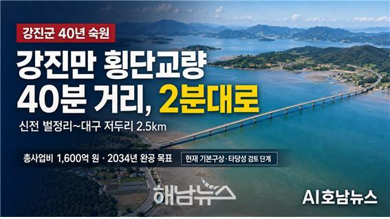 강진만 횡단교량 배너 / 사진제공=AI호남뉴스 |
강진만을 사이에 두고 단절된 강진군 동서 생활권을 직접 연결하는 ‘강진만 횡단교량’ 건설사업이 전남도와 강진군의 공동협약을 거쳐 기본구상과 타당성 검토 단계에 들어갔다.
강진만 횡단교량은 강진군 신전면 벌정리와 대구면 저두리 일원을 연결하는 지방도 819호선 구간에 총연장 2.5㎞, 왕복 2차로 규모로 건설하는 사업이다. 초기 구상은 해상교량 약 1.8㎞와 접속도로 약 700m로 구성되며, 예상 사업비는 약 1천600억 원이다.
사업이 완료되면 강진만 서쪽의 신전·도암 생활권과 동쪽의 대구·마량 생활권이 직접 연결된다. 현재 강진만을 우회해 약 40분이 걸리는 이동시간이 교량 통과 기준 2분대로 줄어들 것으로 전망된다.
다만 ‘40분에서 2분’이라는 표현은 신전면과 대구면 사이를 차량으로 우회하는 시간과 교량 자체 통과시간을 비교한 예상치다. 실제 출발지와 목적지에 따른 전체 이동시간은 달라질 수 있다.
전남도·강진군 공동협약…지방도 추진 시 절반씩 부담
전남도와 강진군은 지난 1월 7일 강진아트홀에서 김영록 전남도지사와 강진원 강진군수, 지방의원, 주민 등 700여 명이 참석한 가운데 ‘강진만 횡단교량 건설사업 공동협약’을 체결했다.
협약에는 두 기관이 사업을 공동 추진하고, 지방도 사업으로 건설할 경우 총사업비를 전남도와 강진군이 각각 50%씩 부담하는 내용이 담겼다.
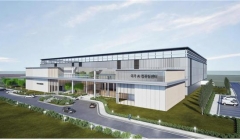
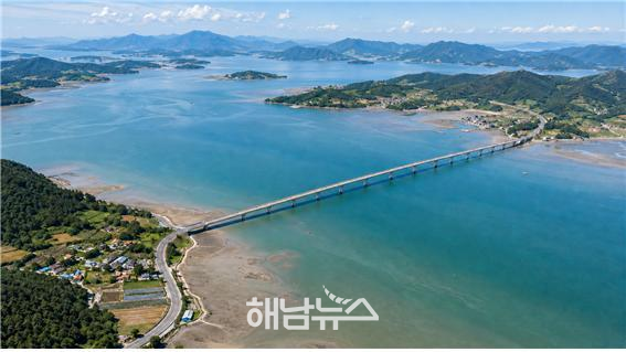 강진만 횡단교량 조감도 / 사진제공=CHAT GPT |
현재 추산 사업비 1천600억 원이 그대로 적용되면 강진군이 부담해야 할 몫은 약 800억 원에 이른다. 기본구상과 설계 과정에서 물가 상승, 교량 형식, 연약지반 처리, 접속도로와 환경보전 대책 등이 반영되면 총사업비가 늘어날 가능성도 있다.
이에 전남도와 강진군은 지방도 사업 추진과 함께 해당 노선을 국도 또는 국가지원지방도로 승격시키는 방안을 병행하기로 했다. 국도·국지도 승격에 성공하면 국비 투입 비율을 높여 전남도와 강진군의 재정부담을 줄일 수 있다.
김영록 전남도지사는 협약 당시 “상당한 액수의 예산이 필요한 만큼 양쪽 연결도로를 국도나 국가지원지방도로 승격시켜 강진군의 부담을 덜도록 노력하겠다.”는 입장을 밝혔다.
전남도는 강진만 횡단교량을 주민 교통복지 향상과 지역 균형발전, 관광·물류 활성화를 이끌 기반시설로 보고 사업 추진에 협력하겠다는 입장이다.
강진군 “40년 숙원”…동서 관광벨트 연결 기대
강진군은 횡단교량 건설을 강진만 동서 지역 주민들의 오랜 숙원사업으로 규정하고 있다.
강진만 서쪽에는 다산초당과 백련사, 도암면과 신전면 관광지가 자리하고 있고, 동쪽에는 가우도와 고려청자박물관, 마량항과 마량놀토수산시장 등이 있다. 그러나 두 권역이 강진만을 사이에 두고 떨어져 있어 관광객이 한 번에 둘러보려면 강진읍 방면으로 크게 우회해야 한다.
교량이 건설되면 다산초당·백련사에서 가우도·청자도요지·마량항으로 이어지는 동서 관광동선이 짧아지고, 주민 통학·통근과 농수산물 운송 여건도 개선될 것으로 기대된다.
방송 인터뷰에 등장한 이호남 씨는 사업을 주관한 인물이 아니라 마량면 주민으로 확인된다. 이 씨는 “같은 강진군인데도 마량·대구에서 신전·도암으로 가는 거리가 너무 멀었다”며 교량 건설에 대한 기대를 밝힌 주민 인터뷰 대상자다. 따라서 ‘이호남 마량면 주관 사업’으로 표현하는 것은 사실과 다르다.
현재는 공사가 아닌 ‘용역 단계’
확인 결과 강진만 횡단교량은 2026년 7월 말 현재 교량 공사에 착수한 상태가 아니다.
강진군은 ‘강진만 횡단교량 건설사업 기본구상 및 타당성 검토 용역’ 절차를 추진하고 있다. 이 용역을 통해 교량과 접속도로의 위치, 교량 형식, 교통수요, 경제성, 환경성, 예상 사업비와 재원 조달 방안 등을 검토하게 된다.
당초 발표된 행정절차는 다음과 같다.
2026년 상반기 기본구상·타당성 검토 착수
2026년 하반기 행정안전부 타당성조사와 지방재정 투자심사 추진
이후 기본·실시설계와 관계기관 협의 진행
2034년 준공 목표
따라서 현재 공개된 총연장 2.5㎞, 사업비 1천600억 원, 해상교량 1.8㎞ 등의 수치는 기본구상 단계의 추정치다. 최종 노선과 교량 형식, 사업비, 착공 시기는 타당성조사와 투자심사, 설계, 환경·해양 관련 협의를 거쳐야 확정된다.
국비 전환과 환경·재정 검증이 핵심
강진만 횡단교량은 생활권 연결과 관광 접근성 개선 효과가 크지만, 안정적인 재원 확보가 사업 성패를 좌우할 전망이다.
강진군이 지방도 방식으로 사업비 절반을 부담할 경우 다른 도로·복지·농수산업 예산에 미칠 영향도 따져봐야 한다. 국도나 국가지원지방도 승격은 국토교통부의 도로망 계획과 사업 타당성 검토를 거쳐야 하므로 공동협약만으로 국비 지원이 확정된 것은 아니다.
강진만은 갯벌과 철새, 수산생물의 서식공간이어서 교량 건설에 따른 해수 흐름과 퇴적환경 변화, 경관 훼손, 어업권 영향도 면밀히 검토해야 한다. 관광 접근성뿐 아니라 실제 교통량과 물류 수요, 유지관리비까지 포함한 편익 분석도 필요하다.
전남도와 강진군은 공동협약 체결을 사업 확정이나 착공으로 과장해서는 안 된다. 기본구상 용역비와 계약기간, 용역 수행기관, 국도·국지도 승격 신청 일정, 행정안전부 타당성조사 결과, 연도별 재원 분담계획을 군민에게 단계별로 공개해야 한다.
특히 강진군은 최대 약 800억 원으로 예상되는 군비 부담이 실제로 가능한지, 국비 확보에 실패하면 지방도 방식으로 계속 추진할 것인지, 총사업비가 늘어날 경우 군비 부담 상한을 어떻게 설정할 것인지 분명한 원칙을 제시해야 한다.
Gangjin Bay Cross-Bay Bridge to Cut 40-Minute Trip to About Two Minutes…Preliminary Planning and Feasibility Review Underway
Proposed 2.5-kilometer section of Provincial Road No. 819 connecting Beoljeong-ri, Sinjeon-myeon, and Jeodu-ri, Daegu-myeon
Initial plan calls for an approximately 1.8-kilometer marine bridge and 700 meters of approach roads with two traffic lanes
Estimated project cost of KRW 160 billion, with phased completion targeted for 2034
South Jeolla Province and Gangjin County sign joint agreement; costs to be split equally if pursued as a provincial road project
Upgrade to a national highway or state-supported provincial road to be pursued to reduce Gangjin County’s financial burden
Expected to connect the Maryang–Daegu and Doam–Sinjeon living zones and cut travel time from about 40 minutes to roughly two minutes
Improved access expected along the east–west tourism corridor linking Dasan Chodang and Baengnyeonsa Temple with Gaudo Island and Maryang Port
Project remains at the preliminary planning and feasibility-review stage, not the construction stage; route and cost are not yet finalized
“National funding strategy, county spending limit, environmental impact, and annual project schedule must be disclosed”
【Gangjin=AI Honam News】 aihnnews@kakao.com
The Gangjin Bay Cross-Bay Bridge project, intended to directly connect communities on the eastern and western sides of Gangjin Bay, has entered the preliminary planning and feasibility-review stage following a joint agreement between South Jeolla Province and Gangjin County.
The proposed bridge would be constructed along a 2.5-kilometer section of Provincial Road No. 819 between Beoljeong-ri in Sinjeon-myeon and Jeodu-ri in Daegu-myeon, Gangjin County. The initial plan calls for a two-lane route comprising approximately 1.8 kilometers of marine bridge and 700 meters of approach roads. The preliminary cost estimate is about KRW 160 billion.
Once completed, the bridge would directly connect the Sinjeon–Doam living zone on the western side of Gangjin Bay with the Daegu–Maryang living zone on the eastern side. The journey, which currently requires an approximately 40-minute detour around the bay, is expected to be reduced to about two minutes for the bridge crossing itself.
However, the phrase “from 40 minutes to two minutes” compares the current driving time required to detour between Sinjeon-myeon and Daegu-myeon with the estimated time needed to cross the proposed bridge. Actual total travel time will vary depending on the point of departure and destination.
South Jeolla Province and Gangjin County to Split Costs Equally if Built as Provincial Road
On January 7, South Jeolla Province and Gangjin County signed a joint agreement for the Gangjin Bay Cross-Bay Bridge project at Gangjin Art Hall. The ceremony was attended by approximately 700 people, including South Jeolla Province Governor Kim Yung-rok, Gangjin County Mayor Kang Jin-won, provincial and county council members, and local residents.
Under the agreement, the two governments will jointly advance the project. If the bridge is constructed as a provincial road project, South Jeolla Province and Gangjin County will each bear 50 percent of the total cost.
Based on the current estimate of KRW 160 billion, Gangjin County’s share would amount to approximately KRW 80 billion. The total project cost could increase as inflation, the final bridge type, soft-ground treatment, approach roads, and environmental-protection measures are incorporated during the planning and design process.
South Jeolla Province and Gangjin County have therefore agreed to pursue an upgrade of the route to either a national highway or a state-supported provincial road while simultaneously preparing to proceed as a provincial road project. If the upgrade is approved, a larger proportion of national funding could be secured, reducing the financial burden on both the provincial and county governments.
Governor Kim Yung-rok said at the signing ceremony, “A substantial amount of funding will be required. We will work to have the connecting roads on both sides upgraded to a national highway or state-supported provincial road to ease Gangjin County’s financial burden.”
South Jeolla Province regards the bridge as essential infrastructure that could improve transportation services for residents, promote balanced regional development, and stimulate tourism and logistics. The provincial government has stated that it will cooperate in advancing the project.
Gangjin County Calls It a “40-Year Aspiration” and Anticipates an East–West Tourism Corridor
Gangjin County describes the proposed bridge as a long-standing aspiration of residents living on both sides of Gangjin Bay.
The western side of the bay includes Dasan Chodang, Baengnyeonsa Temple, and tourist attractions in Doam-myeon and Sinjeon-myeon. The eastern side includes Gaudo Island, the Goryeo Celadon Museum, Maryang Port, and the Maryang Saturday Fish Market.
Because the two areas are separated by Gangjin Bay, visitors who wish to tour attractions on both sides must currently make a lengthy detour toward Gangjin-eup.
If the bridge is built, it would shorten the east–west tourism route linking Dasan Chodang and Baengnyeonsa Temple with Gaudo Island, the celadon kiln sites, and Maryang Port. It is also expected to improve commuting, school transportation, and the movement of agricultural and fisheries products.
Lee Ho-nam, who appeared in a broadcast interview, was confirmed to be a resident of Maryang-myeon, not the person overseeing the project. Lee expressed support for the bridge, saying, “Although we live in the same county, it has been too far to travel from Maryang and Daegu to Sinjeon and Doam.”
It would therefore be inaccurate to describe the project as being organized or led by Lee Ho-nam of Maryang-myeon.
Project Remains at the Study Stage, Not the Construction Stage
As of late July 2026, construction of the Gangjin Bay Cross-Bay Bridge has not begun.
Gangjin County is proceeding with a preliminary planning and feasibility-review study for the project. The study is expected to examine the proposed locations of the bridge and approach roads, the type of bridge, projected traffic demand, economic and environmental feasibility, estimated construction costs, and funding options.
The initially announced administrative schedule is as follows:
Launch of preliminary planning and feasibility review in the first half of 2026
Ministry of the Interior and Safety feasibility study and local-government investment review in the second half of 2026
Basic and detailed design work, followed by consultations with relevant agencies
Targeted completion in 2034
Accordingly, the currently disclosed figures—including the total length of 2.5 kilometers, estimated cost of KRW 160 billion, and approximately 1.8-kilometer marine bridge—remain preliminary estimates.
The final route, bridge type, total cost, and construction schedule will be determined only after the feasibility study, investment review, design process, and environmental and maritime consultations have been completed.
National Funding and Environmental and Fiscal Reviews Will Be Crucial
The Gangjin Bay Cross-Bay Bridge could substantially improve community connectivity and tourism access, but securing a stable funding source will determine whether the project can move forward as planned.
If Gangjin County is required to pay half of the cost under the provincial road approach, officials must assess the potential impact on other road, welfare, agriculture, and fisheries budgets.
Upgrading the route to a national highway or state-supported provincial road requires its inclusion in the Ministry of Land, Infrastructure and Transport’s road network plans and the completion of a separate feasibility review. The joint agreement alone does not guarantee national funding.
Gangjin Bay contains tidal flats that provide habitats for migratory birds, fisheries resources, and numerous marine species. The study must therefore carefully examine how bridge construction could affect tidal flows, sedimentation patterns, coastal scenery, and fishing rights.
In addition to improved tourism access, the feasibility assessment should examine actual traffic and freight demand and include the bridge’s long-term maintenance costs.
South Jeolla Province and Gangjin County must not portray the signing of the joint agreement as final project approval or the start of construction. They should disclose, stage by stage, the preliminary study budget, contract period, contractor, schedule for applying for national highway or state-supported provincial road status, the results of the Ministry of the Interior and Safety’s feasibility study, and the annual funding plan.
In particular, Gangjin County should clearly state whether it can afford the estimated KRW 80 billion county share, whether it would continue the project as a provincial road if national funding is not secured, and what ceiling it would place on the county’s contribution if the total project cost rises.
 해남뉴스 박충배 편집 및 논설위원 news@hbcnews.kr