| “‘王’ 청동인장에 ‘새금관’ 기와까지”…해남 고다산성, 1천년 전 서남해 지방통치 중심지였나 통일신라 고다산성 첫 발굴조사…성벽·문지와 유물 100여 점 확인 해남뉴스 박충배 편집/논설 news@hbcnews.kr |
| 2026년 09월 09일(수) 11:17 |
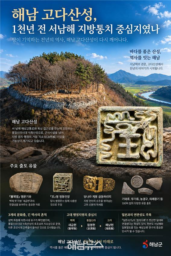 해남 현산 고다산성 포스터 / 사진제공=해남군수 |
[해남=AI호남뉴스] aihnnews@kakao.com
해남 현산면의 산 정상에 자리한 고다산성이 단순한 군사 방어시설을 넘어 통일신라시대 서남해안의 정치·행정을 담당했던 지방통치 거점이었을 가능성을 보여주는 유물들이 대거 출토됐다.
특히 백제시대 이 지역의 옛 행정지명인 ‘새금현(塞琴縣)’과 연결되는 ‘새금관(塞琴官)’ 명문기와를 비롯해 ‘왕(王)’자가 새겨진 청동인장, 중국 당나라 계통의 금동허리띠 등 일반적인 지방 산성에서는 쉽게 보기 어려운 유물이 확인되면서 고다산성의 역사적 위상을 새롭게 평가해야 한다는 분석이 나온다.
해남군은 지난 6월부터 3개월 동안 역사문화권 정비사업의 핵심 유적인 현산면 고다산성을 처음으로 발굴조사한 결과 성벽과 문지 등 주요 유구와 함께 100여 점의 유물을 확인했다고 8일 밝혔다.
이번 조사는 고다산성의 정확한 축조 시기와 구조, 성격을 규명하고 향후 역사문화권 정비와 국가유산 지정에 필요한 학술적 근거를 확보하기 위해 실시됐다.
■ 문헌 속 ‘새금현’이 기와에 나타났다
이번 발굴에서 학술적으로 가장 주목되는 유물 가운데 하나는 ‘새금관(塞琴官)’이라는 글자가 새겨진 기와다.
문헌에는 백제시대 지금의 해남 현산면 일대에 ‘새금현(塞琴縣)’이라는 지방행정구역이 있었던 것으로 기록돼 있다.
이후 통일신라 경덕왕 때 행정구역 개편을 거치면서 침명현(浸溟縣)으로 이름이 바뀌었고 고려시대에는 해남현으로 이어진 것으로 전해진다.
백제 새금현→통일신라 침명현→고려 해남현으로 이어지는 지방행정사의 공간적 중심지가 현재의 현산면 일대였을 가능성이 제기돼 온 것이다.
그런데 이번에는 문헌에만 등장했던 ‘새금’이라는 이름이 실제 고다산성 출토 기와에서 확인됐다.
이에 따라 고다산성과 옛 새금현의 관계를 규명할 수 있는 중요한 고고학적 단서가 확보됐다는 평가가 나온다.
다만 ‘새금관’의 ‘관(官)’이 구체적으로 어떤 관청이나 조직, 제작·사용 주체를 뜻하는지와 명문기와의 정확한 제작연대 등은 추가 연구가 필요하다.
따라서 현재 단계에서 고다산성을 백제 새금현의 치소로 곧바로 확정하기보다는, 문헌에 기록된 새금현과 고다산성을 연결할 수 있는 중요한 실물자료가 발견됐다는 데 의미를 둘 필요가 있다.
■ ‘王’자가 새겨진 청동인장…누가 사용했나
‘왕(王)’자가 새겨진 청동인장도 이번 발굴의 핵심 유물이다.
해남군은 이 인장이 당시 행정문서 등에 사용됐을 가능성이 있는 것으로 보고 있다.
고대사회에서 인장은 행정행위와 권한, 신분 등을 나타내는 중요한 물품으로 사용됐다는 점에서 고다산성이 군사기능뿐 아니라 행정기능까지 수행했을 가능성을 뒷받침하는 자료로 주목된다.
다만 인장에 ‘王’자가 새겨졌다는 이유만으로 왕이 직접 사용한 인장이나 왕실의 공식 인장으로 단정할 수는 없다.
인장의 제작연대와 형태, 금속 성분, 유사 출토품과의 비교 등을 통해 ‘王’의 정확한 의미와 실제 사용자를 규명하는 작업이 필요하다.
■ 당나라식 금동허리띠까지…누가 고다산성에 있었나
중국 당나라 형식의 금동허리띠가 함께 출토된 점도 눈길을 끈다.
금동허리띠와 같은 고급 장신구는 당시 신분과 위계를 나타내는 위세품의 성격이 강하다.
통일신라는 당과 활발하게 교류하면서 정치·문화·복식제도 등에서 영향을 받았으며, 고위 관료층의 복식과 장신구에도 신분질서가 반영됐다.
따라서 고다산성에서 이러한 금동허리띠가 출토됐다는 사실은 상당한 지위의 지방관이나 지배층이 이곳에서 활동했을 가능성을 살펴볼 수 있는 자료가 된다.
여기에 막새를 비롯한 각종 기와류와 무기류, 농경구, 의례용기까지 함께 발견됐다.
명문기와와 인장, 고급 허리띠, 무기, 농경도구, 의례용품이 한 공간에서 확인됐다는 것은 고다산성이 단순히 전쟁 때 병력이 머물던 산성이 아니라 행정과 군사, 생산과 의례 기능까지 복합적으로 수행했던 공간일 가능성을 보여준다.
해남군은 이 같은 출토양상을 토대로 고다산성이 일반적인 지방 관아 수준을 뛰어넘는 위세품을 갖춘 통일신라시대 지방 정치·행정의 거점인 ‘치소성(治所城)’이었을 가능성에 주목하고 있다.
■ 산 정상에 성을 쌓은 이유…바다와 육로를 동시에 본다
고다산성이 자리한 위치도 이 같은 해석을 뒷받침한다.
고다산성은 산 정상부를 둘러싸는 이른바 ‘테뫼식’ 석축산성이다.
이곳에서는 서·남해안으로 이어지는 해상교통로와 내륙으로 연결되는 육상 접근로를 조망할 수 있어 군사·교통상 전략적 가치가 높은 곳으로 평가된다.
북쪽 성벽 외부는 위로 올라갈수록 조금씩 안쪽으로 물리는 ‘들여쌓기’ 방식으로 축조됐고 내부에는 흙을 층층이 다져 올리는 판축(板築) 기법으로 기초를 조성한 뒤 수직으로 성벽을 쌓은 것으로 조사됐다.
이는 통일신라시대 성곽의 축조기술을 보여주는 중요한 자료다.
동쪽 문지는 통일신라시대 처음 설치된 뒤 고려~조선시대에 계단식으로 보수된 흔적도 확인됐다.
고다산성이 한 시대에 만들어졌다가 곧 폐기된 시설이 아니라 시대 변화에 따라 구조와 기능을 바꾸며 오랫동안 활용됐음을 보여주는 대목이다.
■ 성벽 아래에는 마한이 있었다
더욱 주목되는 것은 고다산성에서 서로 다른 시대에 형성된 3개의 문화층이 확인됐다는 점이다.
성벽 아래층에서는 마한시대 유구와 유물이 확인됐다.
이후 통일신라시대에는 본격적인 석축산성이 건설되고 정치·행정 기능을 수행하는 치소성으로 운영된 것으로 조사됐다.
산성이 폐성된 이후에는 담장을 갖춘 조선시대 건축물이 들어선 것으로 파악됐다.
이에 따라 고다산성 일대의 역사는 적어도 마한→백제·통일신라→고려→조선으로 이어지는 해남 서남부지역의 장기적인 정치·교통 변화 속에서 살펴봐야 할 필요성이 커졌다.
특히 현산면 일대에는 고대 고분과 산성 등 여러 유적이 분포하고 있어 고다산성만 독립적으로 연구하기보다 주변 유적과 해상교통로를 함께 분석해야 고대 해남의 실체에 접근할 수 있다는 지적이다.
■ 일본서기 속 ‘침미다례’…해남 현산과 관계 있나
이번 발굴은 한반도 내부의 지방행정사뿐 아니라 고대 서남해와 일본열도를 연결했던 해상교통망 연구에도 새로운 관심을 불러일으킨다.
일본의 고대 사서인 『일본서기』에는 ‘침미다례(忱彌多禮)’라는 지명이 등장한다.
그동안 학계 일각에서는 이 침미다례를 통일신라의 ‘침명현’과 연결하고 현재의 해남 현산면 일대에 비정하는 견해를 제시해 왔다.
현산면 일대가 백제 새금현에서 통일신라 침명현으로 이어졌다는 점을 고려하면 주목할 만한 대목이다.
더욱이 해남은 서해와 남해가 만나는 한반도 서남단에 위치해 중국 연안과 한반도 서남해, 제주도, 일본열도를 오가는 고대 해상교통망을 연구하는 데 지리적으로 중요한 지역이다.
고다산성이 실제로 해상교통로를 조망하고 통제할 수 있는 위치에 있다는 점도 이러한 연구 가능성을 높인다.
그러나 이번 발굴에서 일본과의 직접 교류를 입증하는 유물이 확인됐다고 보기는 어렵다.
또 『일본서기』의 기록 자체도 편찬 시기와 정치적 배경을 고려한 사료비판이 필요하기 때문에 ‘침미다례=현산면’, 더 나아가 ‘침미다례=고다산성’으로 단정해서는 안 된다.
오히려 이번 발굴의 의미는 고다산성이 존재했던 현산면 일대가 고대 서남해의 중요한 정치·행정·교통 거점이었다는 실물자료가 확보되면서 침미다례의 위치와 한반도 서남해-일본열도 교류관계를 다시 검토할 새로운 고고학적 기반이 마련됐다는 데 있다.
■ 왜 현산면이었나…‘바다를 장악하는 자가 서남해를 지배했다’
고다산성의 역사적 가치를 이해하기 위해서는 당시의 교통환경도 살펴봐야 한다.
오늘날에는 도로가 지역을 연결하지만 고대 서남해안에서는 바다가 중요한 교통로였다.
해남과 진도·완도 일대는 수많은 섬과 해협을 따라 서해와 남해가 연결되는 곳이다. 해상으로 이동하는 사람과 물자를 감시하면서 내륙으로 들어오는 육로까지 장악할 수 있는 지점에 정치·군사적 거점이 필요했을 가능성이 크다.
고다산성은 바로 이 같은 조건을 갖추고 있다.
따라서 향후 연구에서는 고다산성을 하나의 산성으로만 볼 것이 아니라 현산면 일대 고분군과 주변 산성, 백포만 등 연안지역, 진도·완도 해역을 연결하는 ‘고대 서남해 해상 네트워크’의 관점에서 접근할 필요가 있다.
■ 국가유산 지정 추진…17일 발굴현장 공개
해남군은 이번 발굴 성과를 토대로 고다산성의 역사적 성격과 가치에 대한 연구를 확대할 방침이다.
특히 역사문화권 정비사업의 방향을 구체화하는 한편 국가유산 지정을 추진해 고다산성을 서·남해안을 대표하는 역사문화유산으로 육성한다는 계획이다.
이번 발굴조사 성과는 오는 17일 오후 2시 현산면 고다산성 발굴현장에서 열리는 현장설명회를 통해 일반에 공개될 예정이다.
향후 연구의 핵심은 명확하다.
‘새금관’ 명문기와의 정확한 제작시기와 ‘官’의 의미, ‘王’명 청동인장의 실제 사용 주체, 당나라 계통 금동허리띠의 제작기법과 유통경로를 규명해야 한다.
또 백제 새금현의 치소와 고다산성의 관계, 통일신라 침명현으로 이어지는 행정구역 변화, 현산면 일대 고분·산성과의 관계도 종합적으로 연구할 필요가 있다.
특히 『일본서기』의 침미다례 비정 문제와 서남해 해상교통망까지 연구 범위를 확대할 경우 고다산성은 해남지역의 산성 하나를 넘어 고대 한반도 서남부의 지방통치체계와 중국·한반도·일본열도를 연결했던 해양교류사를 규명할 주요 유적으로 부상할 가능성이 있다.
이번 첫 발굴은 고다산성에 대한 결론이 아니라 시작에 가깝다.
땅속에서 나온 ‘새금관’이라는 네 글자와 ‘王’자가 새겨진 작은 청동인장, 그리고 금동허리띠가 “1천여 년 전 해남 현산에는 누가 있었으며, 이들은 어떤 권한으로 서남해의 바다와 육지를 바라보고 있었는가.”라는 새로운 질문을 던지고 있다.
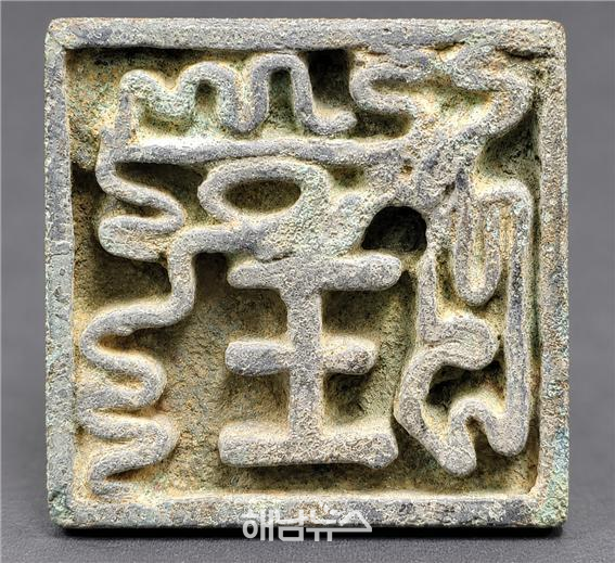 해남군 현산면 청동인장 / 사진제공=해남군수 |
[In-Depth Spotlight]
“‘王’ Bronze Seal and ‘Saegum-gwan’ Roof Tile Unearthed”…Was Haenam’s Goda Fortress a Regional Administrative Hub 1,000 Years Ago?
First excavation of Goda Fortress from the Unified Silla period reveals fortress walls, gate remains and more than 100 artifacts
Roof tile inscribed with ‘塞琴官’ linked to ancient Baekje place name Saegum-hyeon draws attention
Bronze seal inscribed with ‘王’ and Tang-style gilt-bronze belt fittings suggest prestige beyond an ordinary local fortress
Three cultural layers identified, from Mahan remains to a Unified Silla stone fortress and Joseon-period buildings
Strategic location overlooking both western and southern sea routes and inland access raises possibility of a chiso fortress, or regional administrative stronghold
Hyeonsan area traces an administrative lineage from Baekje’s Saegum-hyeon to Silla’s Chimmyeong-hyeon and later Goryeo’s Haenam-hyeon
Scholarly theories linking the area to “Chimmidarye” in the Nihon Shoki renew interest in maritime exchanges between the Korean Peninsula and the Japanese archipelago
Haenam County to pursue national heritage designation…excavation results to be unveiled on site on Sept. 17
[Haenam=AI Honam News] aihnnews@kakao.com
A large number of artifacts unearthed from Goda Fortress, located on a mountaintop in Hyeonsan-myeon, Haenam, are raising the possibility that the site was more than a military stronghold and may have served as a political and administrative center governing Korea’s southwestern coast during the Unified Silla period.
Among the most notable finds are a roof tile bearing the inscription “Saegum-gwan (塞琴官),” which appears to be connected with the ancient Baekje administrative district of Saegum-hyeon (塞琴縣), a bronze seal engraved with the Chinese character “王” meaning “king,” and Tang Dynasty-style gilt-bronze belt fittings. Because such objects are uncommon at ordinary local fortresses, the discovery is prompting a reassessment of Goda Fortress’s historical status.
Haenam County said on Sept. 8 that it conducted the first excavation of Goda Fortress for three months beginning in June as part of a historical and cultural heritage restoration project. The excavation uncovered major structural remains, including fortress walls and gate sites, along with more than 100 artifacts.
The project was undertaken to determine the fortress’s date of construction, architectural structure and historical function, while securing academic evidence for future restoration work and possible designation as a national heritage site.
Ancient “Saegum-hyeon” Appears on a Roof Tile
One of the most academically significant discoveries is a roof tile bearing the inscription “Saegum-gwan (塞琴官).”
Historical records indicate that during the Baekje period, the area corresponding to present-day Hyeonsan-myeon in Haenam was organized as an administrative district called Saegum-hyeon (塞琴縣).
Following an administrative reorganization under King Gyeongdeok of Unified Silla, the district was renamed Chimmyeong-hyeon (浸溟縣), and later developed into Haenam-hyeon during the Goryeo period.
Scholars have long suggested that the Hyeonsan area may have been the spatial center of a local administrative system that evolved from Baekje’s Saegum-hyeon to Unified Silla’s Chimmyeong-hyeon and eventually Goryeo’s Haenam-hyeon.
This excavation is significant because the name “Saegum,” previously known primarily from historical texts, has now been identified on an actual roof tile excavated from Goda Fortress.
The discovery is therefore being regarded as an important archaeological clue that could help clarify the relationship between Goda Fortress and the ancient administrative district of Saegum-hyeon.
However, further research is needed to determine what the final character “官,” meaning “government office” or “official institution,” specifically referred to, as well as the exact date of manufacture of the inscribed tile.
At this stage, it would be premature to conclude that Goda Fortress was definitively the administrative seat of Baekje’s Saegum-hyeon. Its significance lies instead in providing tangible evidence that may connect the fortress with the historically recorded district.
Who Used the Bronze Seal Inscribed with “王”?
The bronze seal engraved with the character “王” is another key discovery.
Haenam County believes the seal may have been used in administrative documents or official affairs at the time.
In ancient societies, seals often symbolized administrative authority, official status and power. The presence of such an object therefore supports the possibility that Goda Fortress fulfilled not only a military role but also an administrative one.
However, the inscription “王” alone does not mean that the seal was personally used by a king or was an official royal seal.
Determining its exact significance and user will require further analysis of its manufacturing period, shape, metal composition and comparison with similar excavated artifacts.
Tang-Style Gilt-Bronze Belt Fittings…Who Lived at Goda Fortress?
The discovery of Tang Dynasty-style gilt-bronze belt fittings is also attracting considerable attention.
Such luxury ornaments were closely associated with social status and rank.
Unified Silla maintained active political and cultural exchanges with Tang China, and Tang influences were reflected in political institutions, dress regulations and elite accessories.
The presence of such belt fittings at Goda Fortress may therefore suggest that high-ranking local officials or members of the ruling elite were stationed there.
Other finds included decorated roof-end tiles, various roof tiles, weapons, agricultural tools and ritual vessels.
The combination of inscribed tiles, an official-looking seal, elite belt ornaments, weapons, farming implements and ritual objects from a single site suggests that Goda Fortress may have functioned as a complex center combining administration, military defense, production and ceremonial activity rather than serving merely as a wartime military post.
Based on these findings, Haenam County is focusing on the possibility that Goda Fortress functioned as a “chiso-seong (治所城),” a fortress that served as a regional political and administrative center during the Unified Silla period.
Why Build a Fortress on the Summit? To Watch Both Sea and Land
The location of Goda Fortress further supports this interpretation.
Goda Fortress is a stone fortress of the so-called “temoe” type, encircling the summit area of a mountain.
From the site, it is possible to observe maritime routes leading through Korea’s western and southern coasts as well as inland access routes, giving the location considerable strategic value for both military defense and transportation.
The exterior of the northern fortress wall was built using an inward-stepped method, in which the wall receded slightly as it rose. The interior foundation was reinforced using rammed-earth techniques before being vertically stacked with stone.
These construction methods reflect characteristic features of Unified Silla fortress architecture.
The eastern gate is believed to have been established during the Unified Silla period and later repaired in a stepped form during the Goryeo and Joseon periods.
This indicates that Goda Fortress was not a facility used briefly in a single period but was modified and reused over a long span of time as its role and structure evolved.
Beneath the Fortress Wall Lay Mahan
Another remarkable feature of the excavation is the identification of three distinct cultural layers from different historical periods.
Archaeological remains and artifacts from the Mahan period were found beneath the fortress wall.
During the Unified Silla period, a major stone fortress was then constructed at the site and appears to have functioned as a political and administrative center.
After the fortress was abandoned, a Joseon-period building complex enclosed by walls was established on the site.
This suggests that the history of the Goda Fortress area should be understood within a long-term regional transformation extending through Mahan, Baekje, Unified Silla, Goryeo and Joseon.
The Hyeonsan area also contains a number of ancient burial sites and fortresses, meaning Goda Fortress should not be studied in isolation. A broader analysis of nearby archaeological sites and maritime routes will likely be necessary to reconstruct the ancient history of Haenam.
Could the “Chimmidarye” in the Nihon Shoki Refer to Hyeonsan, Haenam?
The excavation has also renewed interest not only in regional administrative history on the Korean Peninsula, but also in ancient maritime networks linking Korea’s southwestern coast with the Japanese archipelago.
The ancient Japanese chronicle Nihon Shoki refers to a place called “Chimmidarye (忱彌多禮).”
Some scholars have proposed that Chimmidarye may be related to Chimmyeong-hyeon of Unified Silla and may correspond to the present-day Hyeonsan area of Haenam.
This is especially notable because Hyeonsan is historically linked to Baekje’s Saegum-hyeon and later Unified Silla’s Chimmyeong-hyeon.
Geographically, Haenam lies at the southwestern tip of the Korean Peninsula where western and southern maritime routes converge, making the region strategically important for understanding ancient seaborne networks connecting coastal China, southwestern Korea, Jeju Island and the Japanese archipelago.
The location of Goda Fortress, which commanded a view over major maritime routes, further strengthens the possibility that the site played an important role in controlling or monitoring ancient sea traffic.
However, the current excavation has not produced artifacts that directly prove exchanges with Japan.
In addition, references in the Nihon Shoki require careful source criticism because of the chronicle’s compilation date and political context. It would therefore be inappropriate to conclude that “Chimmidarye equals Hyeonsan,” much less that “Chimmidarye equals Goda Fortress.”
Rather, the significance of the latest excavation is that it provides new archaeological evidence that the Hyeonsan area was an important political, administrative and transportation center on the ancient southwestern coast, creating a stronger foundation for renewed research into the location of Chimmidarye and maritime exchanges between the Korean Peninsula and the Japanese archipelago.
Why Hyeonsan? “Whoever Controlled the Sea Controlled the Southwest”
To fully understand the historical significance of Goda Fortress, the transportation environment of the period must also be considered.
Today, roads serve as the main arteries connecting regions. In ancient southwestern Korea, however, the sea was one of the most important transportation routes.
The seas around Haenam, Jindo and Wando form a dense network of islands, channels and straits linking the Yellow Sea and the South Sea.
A strategic stronghold capable of monitoring people and goods moving by sea while also controlling inland access routes would have been of great political and military importance.
Goda Fortress was located in precisely such a position.
Future research should therefore examine the fortress not as an isolated site, but within a broader “ancient southwestern maritime network” linking burial sites and neighboring fortresses in Hyeonsan, coastal areas such as Baekpo Bay, and the waters around Jindo and Wando.
Haenam to Pursue National Heritage Designation…Excavation Site Opens Sept. 17
Haenam County plans to expand academic research into the historical function and significance of Goda Fortress based on the latest findings.
The county will also use the excavation results to shape future historical and cultural restoration projects and plans to pursue designation of Goda Fortress as a national heritage site, with the goal of developing it into a major historical and cultural landmark representing Korea’s western and southern coasts.
The excavation results will be presented to the public during an on-site briefing at Goda Fortress in Hyeonsan-myeon at 2 p.m. on Sept. 17.
Several major questions remain for future research.
Scholars will need to determine the exact date of the “Saegum-gwan” roof tile and the precise meaning of the character “官,” identify who actually used the bronze seal engraved with “王,” and analyze the manufacturing techniques and distribution route of the Tang-style gilt-bronze belt fittings.
Further investigation is also needed into the relationship between Goda Fortress and the administrative seat of Baekje’s Saegum-hyeon, the transition to Unified Silla’s Chimmyeong-hyeon, and connections with nearby burial sites and fortresses in Hyeonsan.
If research is expanded to include the debated identification of Chimmidarye in the Nihon Shoki and the broader maritime traffic network of southwestern Korea, Goda Fortress could emerge as a key archaeological site for understanding not only the regional governance system of ancient southwestern Korea but also the maritime history linking China, the Korean Peninsula and the Japanese archipelago.
This first excavation is therefore closer to a beginning than a conclusion.
The four-character inscription “Saegum-gwan,” a small bronze seal bearing the character “王,” and a set of gilt-bronze belt fittings unearthed from the soil are now raising a new historical question:
“Who stood here in Hyeonsan more than 1,000 years ago, and under what authority did they look out over the seas and roads of Korea’s southwestern frontier?”
 해남뉴스 박충배 편집/논설 news@hbcnews.kr